Edinburgh is, by most measures, the most walkable city in the United Kingdom and a serious contender across Europe. The Old Town and New Town — the two UNESCO-listed halves of the historic centre — are stitched together in barely a square mile. Almost every major sight is reachable on foot from anywhere central. The streets are dense with detail, the skyline rewards every angle, and the rhythm of the city is built around pedestrians, not cars. This guide explains why walking Edinburgh walkable is more than a tourist’s hopeful claim, what to wear, which routes to plan, which apps and maps work best, and how to make the most of one of the great walking cities in the world.
Why Edinburgh Is So Walkable
Three accidents of history made Edinburgh the walking city it is today.
First, the geography. The Old Town clings to a narrow volcanic ridge that runs east to west — the Royal Mile is literally a long, mile-long spine of stone. Buildings grew tall instead of sprawling outward (12-storey medieval tenements were normal here). Distances between the must-see landmarks rarely exceed five minutes’ walk.
Second, the New Town. When Edinburgh expanded north of the Nor’ Loch in the late 18th century, architect James Craig laid out a geometric grid of squares, terraces and gardens that has no rival in scale anywhere in Britain. It is flat (relatively speaking), the pavements are wide, the sight-lines are spectacular, and the entire neighbourhood is a UNESCO World Heritage site you can wander through for hours.
Third, the modern compactness. Edinburgh’s population is around 540,000 — small enough that the historic centre has not been swamped by suburban sprawl, and pedestrian-prioritising decisions (the closure of Princes Street to most cars, the introduction of low-traffic neighbourhoods, the slow tram extension) have kept the centre walkable in 2026 the way it was in 1826.
The Numbers That Make Edinburgh Walkable
To put concrete numbers on this:
- From Edinburgh Castle to the Palace of Holyroodhouse is exactly one mile down the Royal Mile — about 20 minutes downhill.
- From Waverley Station to the Castle is 12 minutes, including the climb up Cockburn Street and the Mound.
- From Princes Street to Arthur’s Seat summit is 45 minutes brisk walk plus the climb itself (another 30 minutes).
- From St Andrew Square to Stockbridge is 15 minutes through the New Town.
- From Stockbridge to the Royal Botanic Garden is another 5 minutes.
- From Tollcross to the Meadows to Old Town is 15 minutes through one of Edinburgh’s loveliest green spaces.
If you stayed centrally, you could see all the must-do sights of Edinburgh on foot without using a single bus or tram. Most visitors do exactly that for the first day or two.
The Topography Question: Yes, Edinburgh Has Hills
Walking in Edinburgh is not entirely flat. The Old Town sits about 30 metres above the New Town. The Mound — the artificial earthen causeway that connects Princes Street to the Royal Mile — climbs at roughly 1:8 gradient. The Royal Mile itself slopes gradually downhill from the Castle (135 m above sea level) to Holyrood (around 30 m). Calton Hill is a 100-metre climb. Arthur’s Seat tops out at 251 m.
If you are not comfortable with hills, your route choice matters. Princes Street, Queen Street, George Street and the wider New Town are flat. The Royal Mile is downhill east-to-west and uphill west-to-east. The Mound and Cockburn Street are the main climb routes from the New Town into the Old. Stockbridge is reachable via a gentle downhill along Hanover Street and Dundas Street. The Water of Leith Walkway is essentially flat for its entire length.
What to Wear: The Edinburgh Walking Kit
Edinburgh’s weather is famously variable — visitors often joke that the city has all four seasons in a single afternoon, and it is rarely an exaggeration. Walking gear that handles unpredictable conditions makes a real difference.
Footwear
Closed-toe walking shoes or trainers with proper grip are essential. Edinburgh’s pavements are often setts (the local term for cobbles) or wet flagstones, and they can be slippery even when not obviously wet. Heels are a mistake on the Royal Mile. Hiking boots are overkill in the city centre but reasonable for Arthur’s Seat or the Pentlands. A waterproof shoe is genuinely useful — drizzle is the default state of Edinburgh weather.
Outerwear
A lightweight waterproof jacket is the most useful single garment for an Edinburgh visitor. Pack it whatever the forecast says. Layering works better than heavy coats; days that start at 8°C and climb to 18°C in summer (and back down to 12°C by evening) are normal. A pocket-friendly umbrella works in light drizzle but is hopeless in the city’s wind tunnels around Princes Street.
Smaller Practicalities
A small daypack is more useful than a handbag — your hands are free for cameras, maps and railings on the steeper closes. Sunglasses are useful in any season because of how low the sun sits in northern latitudes. In winter, gloves, a beanie and a scarf are non-negotiable. Sunscreen is sensible from April to September if you plan to be outdoors all day.
Walking Route 1: The Classic Royal Mile Descent
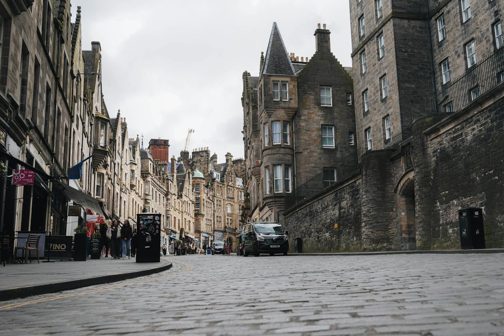
Start at Edinburgh Castle Esplanade (allow at least two hours inside the Castle before this walk if you want to combine them). Walk east along Castlehill, into Lawnmarket, then High Street, then Canongate. The street changes name four times along the way but the route is unbroken. Highlights from west to east include:
- The Hub and the former Tolbooth Kirk at the top of Castlehill.
- Camera Obscura and the Scotch Whisky Experience, side by side at Castlehill.
- Gladstone’s Land (a perfectly preserved 17th-century tenement, run by the National Trust).
- The Writers’ Museum just off Lawnmarket via Lady Stair’s Close.
- St Giles’ Cathedral on High Street, with its distinctive crown spire.
- The Real Mary King’s Close for an underground tour of a 17th-century street.
- John Knox House, the only surviving medieval house on the Mile.
- Canongate Kirk and the Museum of Edinburgh.
- The Scottish Parliament at the foot of the Mile, opposite Holyrood.
- Palace of Holyroodhouse at the very end.
The Royal Mile is one mile long, mostly downhill, and takes 30 minutes of pure walking — but you will need three hours to do it justice if you stop to look inside even a handful of buildings.
Walking Route 2: The New Town Architectural Walk
Start at St Andrew Square. Walk west along George Street, taking in the symmetry of Edinburgh’s principal Georgian shopping and dining street. At the end of George Street, you arrive at Charlotte Square — possibly Britain’s finest Georgian square, with the Bute House Prime Minister’s residence at number 6. From Charlotte Square, walk north into Moray Place, then west to Ainslie Place and Randolph Crescent — the elegantly curved ‘Moray Estate’ development of the 1820s. Continue down to Stockbridge via Royal Circus or India Place. From Stockbridge, return via Dundas Street and Queen Street back to your start. Allow 1.5–2 hours including coffee stops.
Walking Route 3: The Water of Leith Walkway
One of Edinburgh’s loveliest hidden walks. The Water of Leith is a small river that flows from the Pentland Hills through the western and northern parts of the city to Leith Docks. A 12-mile walkway follows it, mostly tarmac, mostly traffic-free, mostly under tree canopy. For a half-day visitor walk, start at Stockbridge, head west to Dean Village (the picture-postcard cluster of half-timbered houses around the old grain mill), continue past Dean Bridge to the Modern One and Modern Two galleries, and finish at Roseburn for a return tram or bus into the centre. About 3.5 miles total, 90 minutes of walking, almost entirely level.
Walking Route 4: Arthur’s Seat and Salisbury Crags
The defining walk of Edinburgh. From Holyrood, several paths climb the volcanic plug that dominates the city skyline. The most popular route — past the Hunter’s Bog and the Radical Road below the Crags — is around 90 minutes round trip with about 230 metres of ascent. Wear proper shoes. Take water in summer. The view from the summit takes in the Firth of Forth, Fife, the Pentland Hills, the city centre and (on clear days) the distant outline of Ben Lomond. Almost no other capital city has anything comparable so close to the centre.
Walking Route 5: Calton Hill at Sunset
Calton Hill rises 100 metres above Princes Street and is reachable from Waterloo Place via a switchback path. The summit hosts the National Monument (Edinburgh’s “unfinished Parthenon”), the Nelson Monument, the Dugald Stewart Monument and several observatories. The view of the Old Town silhouette is the most photographed in Edinburgh, especially at sunset. Round trip from Princes Street is 30–40 minutes plus time at the top.
Walking Route 6: Princes Street Gardens and the Castle Loop
A short, sheltered, family-friendly walk that takes in some of the city’s best views. Enter Princes Street Gardens from the Mound or West Princes Street steps, walk west along the lower path through the gardens, climb up to the Castle Esplanade via Johnston Terrace, then descend back via the Grassmarket and Cowgate. Roughly two hours including stops, lots of photo opportunities, very rewarding even in rain because most of the route has tree cover or stone arcades.
Walking Route 7: The Closes and Wynds of the Old Town
The Royal Mile is fed by dozens of narrow side-streets called “closes” (gated alleys) and “wynds” (open lanes). Most are public and free to walk through. The most rewarding to explore include Advocate’s Close (panoramic photo spot of the New Town), Lady Stair’s Close, Brodie’s Close, Anchor Close, Fleshmarket Close (a stepped close that drops to Cockburn Street) and Old Fishmarket Close. You can lose an afternoon weaving back and forth between High Street and Cockburn Street through these passages, with surprises around every corner.
Pedestrianised Streets and Quiet Routes
Several parts of central Edinburgh are wholly or partly pedestrianised:
- Rose Street: a parallel street to Princes Street, lined with pubs and small shops, almost entirely pedestrian.
- Cockburn Street: the picturesque curving street between Waverley and the Royal Mile, fully pedestrian.
- The Grassmarket: open to traffic but with broad pavements and a piazza atmosphere.
- Multrees Walk: the high-end shopping street next to St Andrew Square, fully pedestrian.
- St Andrew Square gardens: traffic-free interior with cafés and shaded benches.
- George Street central pedestrian zone: the central reservation has been redesigned with wider pavements and benches.
Walking With Children
Edinburgh works brilliantly for families on foot. The Old Town’s twists and turns delight children, and the dense concentration of attractions means you can string several together without long boring walks. Useful family routes include:
- Royal Mile from Castle to Holyrood (with stops at Camera Obscura, Mary King’s Close and the Museum of Childhood).
- Princes Street Gardens with the Ross Fountain and the Floral Clock.
- The Meadows (a 25-hectare park) for picnics, kite-flying and the Meadows Festival in June.
- Royal Botanic Garden in Stockbridge — flat, free, with a pond and adventure-style planting.
- Holyrood Park — gentle paths around Dunsapie Loch for younger kids; Salisbury Crags for older ones.
Pushchairs cope with most central streets but the Royal Mile has setts (cobbles) that are bumpy, and the closes are sometimes stepped. Folding pushchairs and slings are the most flexible options.
Accessibility on Foot
Edinburgh’s medieval geography makes step-free walking challenging in places, but the council has invested in dropped kerbs across the centre and Princes Street is fully step-free. The closes vary — some have ramps, others are stepped. For wheelchair users, the New Town is generally easier than the Old Town, and the tram is the most accessible way to move between them. The Disabled Persons’ Railcard, Companion Card and reduced-mobility taxi options supplement walking for those who need it.
Walking Tours and Guided Walks
Self-guided walking is brilliant, but joining a guided tour deepens the experience. Recommended operators include:
- Sandemans New Europe — the free walking tour (tip-based) is a classic introduction, 3 hours.
- Mercat Tours — historic ghost and underground tours from a permanent base on the Royal Mile.
- The Cadies & Witchery Tours — costumed history walks, very theatrical.
- City of the Dead Tours — cemetery and underground tours.
- Edinburgh Photography Tours — half-day photo walks at golden hour.
- Invisible Edinburgh — guided walks led by people with experience of homelessness, addressing the city’s social history.
- Eat Walk Edinburgh — small-group food walks, 3 hours with five tastings.
Maps and Apps for Walking
Google Maps works well for navigation but does not show every close. Citymapper integrates Lothian’s open data feed and is the favourite of locals. Maps.me offers offline maps that work without data — useful if you are roaming. Apple Maps’ walking directions are decent but lag behind Google in detail. The Edinburgh World Heritage app has a curated ‘closes of the Royal Mile’ tour. Strava and AllTrails both have crowdsourced routes for Arthur’s Seat and the Water of Leith.
Best Time of Day to Walk
Edinburgh’s light is at its best at the two ends of the day. Sunrise over Arthur’s Seat (4:30am in June, 8:30am in December) is unforgettable. Sunset from Calton Hill or the Castle ramparts is the most-photographed Edinburgh experience. Midday walks are fine but the Royal Mile is busiest from about 11:00 to 16:00 from Easter onwards. For a calmer Royal Mile experience, walk it before 09:30 or after 18:00.
Walking in the Rain
Edinburgh has rain on about 175 days a year, so any extended visit will probably include a wet day. Walks that work in the rain include:
- The Royal Mile, where you can duck into closes and pubs for shelter.
- Princes Street, sheltered by shop awnings and underpasses.
- The Grassmarket and Victoria Street, dense with pubs and cafés.
- The closes and wynds of the Old Town, often dry under arches.
- Multrees Walk and Princes Mall (effectively indoor walks).
If the weather turns really nasty, the National Museum of Scotland, the Scottish National Gallery, the Modern art galleries and the Royal Botanic Garden glasshouses are all free and dry.
Safety Considerations
Edinburgh is one of the safest UK cities to walk in. Petty theft happens — keep wallets in front pockets in busy festival crowds — but violent crime is rare in central areas. The biggest practical risks for walkers are slippery wet flagstones and uneven pavements (especially in the Old Town closes). Wear proper shoes, watch your footing on steps, and use handrails. After dark, Princes Street and the Royal Mile are well-lit and busy; the quieter lanes around the Cowgate are less so, particularly on weekend nights when nightlife crowds gather.
Walking Beyond the Centre
Edinburgh’s walking opportunities extend well beyond the historic centre.
- Portobello Promenade: three miles of Victorian seafront, 20 minutes by bus from the centre.
- Cramond: a fishing village with a tidal island, accessible from the centre via the bus 41.
- Pentland Hills: the city’s own range, a 30-minute bus ride from Princes Street.
- Corstorphine Hill: a forested ridge with views, accessible from the airport tram line.
- Blackford Hill and the Hermitage of Braid: woodland and grassland with a Royal Observatory at the top.
Pubs, Cafés and Refuelling on Walks
Edinburgh’s walking culture is fuelled by a remarkable density of pubs and independent cafés. Some walking favourites:
- Hula Juice Bar at the foot of Victoria Street — a great smoothie stop before climbing back to the Royal Mile.
- The Elephant House on George IV Bridge — famous for the J.K. Rowling association.
- The Sheep Heid Inn in Duddingston — Edinburgh’s oldest pub, an ideal halfway stop on the Arthur’s Seat loop.
- The Last Word Saloon in Stockbridge — perfectly placed at the end of the New Town walk.
- Söderberg on George Street — Swedish bakery on the New Town route.
- Lovecrumbs on West Port — cake and coffee on the Grassmarket loop.
Walking Distance Cheatsheet
- Castle to Holyrood: 1 mile / 20 minutes downhill
- Waverley to Castle: 0.5 miles / 12 minutes
- Princes Street to Stockbridge: 0.7 miles / 15 minutes
- Stockbridge to Botanic Garden: 0.2 miles / 5 minutes
- Old Town to Meadows: 0.5 miles / 10 minutes
- Old Town to Calton Hill summit: 1 mile / 25 minutes
- Old Town to Arthur’s Seat summit: 1.5 miles / 1 hour with climb
- Old Town to Dean Village: 1 mile / 25 minutes
- Old Town to Leith Shore: 2.5 miles / 50 minutes
Frequently Asked Questions
Is Edinburgh a walkable city?
Yes — the historic centre is compact, dense and largely pedestrian-prioritising. Most must-see sights are within a 20-minute walk of each other.
How long does it take to walk the Royal Mile?
The Royal Mile is one mile long and takes about 20 minutes of pure walking from Castle to Holyrood — but allow 2–3 hours if you stop to explore.
Is Edinburgh hilly to walk?
Yes in parts. The Old Town sits 30 m above the New Town. The Mound and Cockburn Street are the main climbing routes. The New Town itself is relatively flat.
What shoes should I wear walking in Edinburgh?
Closed-toe trainers or walking shoes with grip. Heels are a mistake on the cobbles. Hiking boots are useful for Arthur’s Seat.
How long does it take to walk up Arthur’s Seat?
30–40 minutes from Holyrood Palace to the summit, depending on route. Around 90 minutes total round trip.
Can you walk from Edinburgh Airport to the city centre?
Technically yes (about 12 km / 7.5 miles) but it is not recommended with luggage. Use the tram, Airlink or a taxi.
What is the best walking tour in Edinburgh?
Sandemans free walking tour for an introduction. Mercat Tours for historic ghost walks. Invisible Edinburgh for a different perspective.
Is walking in Edinburgh safe at night?
Yes in central areas — Princes Street, the Royal Mile and the New Town are well-lit and busy. The Cowgate after midnight is the rowdier zone.
Can I walk to the Royal Botanic Garden from the centre?
Yes — about 25 minutes north from Princes Street via Dundas Street and Stockbridge.
What’s the most beautiful walk in Edinburgh?
Subjective, but the Stockbridge to Dean Village walk along the Water of Leith and the Calton Hill loop at sunset are perennial favourites.
Final Word: Walk First, Bus Second
Edinburgh rewards walkers more than perhaps any other UK city. The density of detail, the changes in level, the surprise of every close opening onto a new view — these are the things that make walking here feel like a small adventure rather than a slog between landmarks. For most visitors, the right pattern is to walk for the first two days, learn the geometry of the city on foot, then start using the tram or the bus to extend your reach. By day three you will be choosing routes based on photogenic light or interesting closes rather than shortest distance — which is the moment you have started to see Edinburgh the way locals do.
Combine this guide with our deeper looks at Edinburgh buses & trams, transport passes, and our ready-made itineraries for the full picture of how to navigate Edinburgh.